Weather Blog: Latest on Milton and how it could impact the CSRA
Milton is expected to stay well south of the CSRA, but it will lead to gusty winds Thursday for our area.
AUGUSTA, Ga. (WRDW/WAGT) - Hurricane Milton is a major talking point this week, following shortly after catastrophic Hurricane Helene.
KEYNOTE:
The CSRA can expect impacts from Hurricane Milton in the form of wind gusts up to 30 mph. Any vulnerable leaning trees will be susceptible to these winds and cause further damage. I want to note Milton’s strength once it es through Florida and into the Atlantic will be much weaker than Helene. We will also be on the left side of the storm this time which is significantly weaker than the right which we saw with Helene.
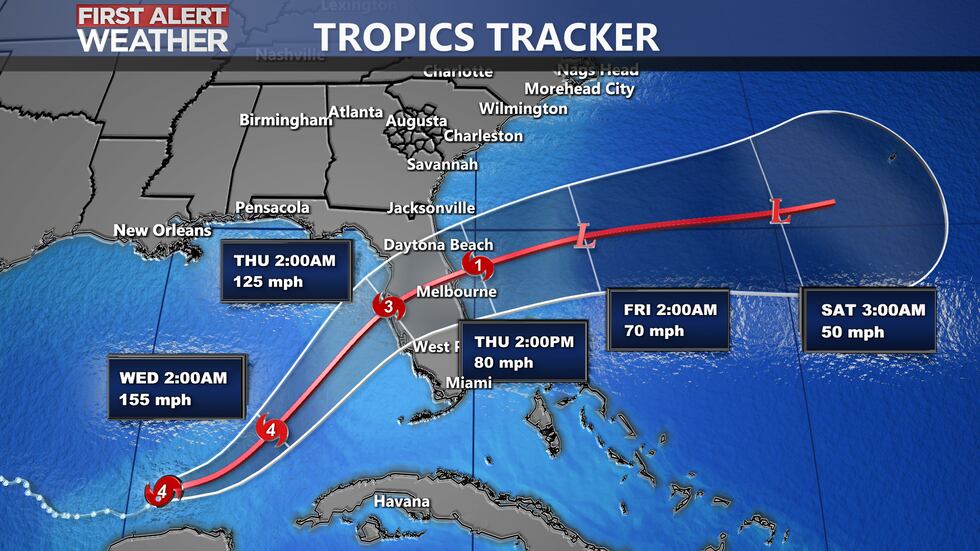
The path of Milton has it moving over the state of Florida and into the Atlantic by late Wednesday evening into Thursday morning. The potential for wind gusts reaching 25-35 mph will come early Thursday morning and last through most of the day. Keep in mind that wind gusts from Helene reached 80-100 mph when it moved through the CSRA.

Milton formed in the Gulf of Mexico as a tropical depression on October 5th, less than 24 hours later Milton became a Category 1 hurricane. At 1 am on October 7th Milton was a Category 1 and just 10 hours later it strengthened into a powerful Category 5 storm with wind speeds reaching 180 mph. The lowest pressure from Milton recorded so far is 897 MB. Just for comparison here is a chart of the top 5 strongest hurricanes based on pressure.
| Hurricane Name (year) | Lowest Pressure |
|---|---|
| Wilma (2005) | 882 mb |
| Gilbert (1988) | 888 mb |
| Labor Day (1935) | 892 mb |
| Rita (2005) | 895 mb |
| Milton (2024) | 897 mb |
Here is an exert from the National Hurricane Center’s 10 pm Monday Update:
“Both Air Force and NOAA Hurricane Hunter aircraft have been investigating Milton. Earlier, the Hurricane Hunters found that the minimum central pressure in the eye had dropped to an estimated 897 mb. Based on this, Milton had the fifth lowest central pressure in the Atlantic basin hurricane record. Subsequent center penetrations by the aircraft indicated somewhat higher central pressures. Also, flight-level and dropsonde data from the aircraft suggested some decrease in intensity, and the advisory intensity is set to 145 kt. The decrease is likely the result of an eyewall replacement reported by the Hurricane Hunters, leading to a double wind maximum radially from the center. Notwithstanding, Milton still remains an extremely dangerous Category 5 hurricane.”
Milton is currently going through an eyewall replacement cycle which has the pressure rising and wind speeds weakening slightly. Eyewall replacement cycles usually lead to the storm weakening some, but it can also lead to the wind field expanding. According to recent research from NOAA, “The processes that cause the newer, larger eyewall to form during an ERC are not well understood.”
Based on the NHC forecast - Milton will likely maintain major hurricane strength before landfall late Wednesday. As of 9am Tuesday, the maximum sustained winds have dropped to 155 mph.
Copyright 2024 WRDW/WAGT. All rights reserved.


