Daily forecast | From First Alert Chief Meteorologist Riley Hale
Near record highs Friday and Saturday. FIRST ALERT for severe storms and flood risk Sunday - Monday.
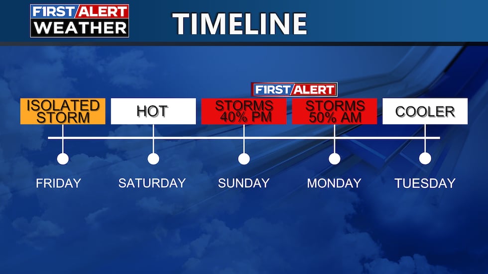
AUGUSTA, Ga. (WRDW/WAGT) - Near record high temperatures are expected today through Sunday. Severe storms and flash floods are possible late Sunday into early Monday as a cold front moves through the region. A FIRST ALERT has been issued for Sunday evening into early Monday for the risk of severe storms and flood risk.
Friday and Saturday will be warm with highs close to 90°. Isolated showers and storms will be possible Friday afternoon/evening. Looking dry Saturday with partly cloudy skies. Morning lows will also be well above average for this time of year in the mid-60s. Patchy dense fog will be possible near sunrise.
A cold front will bring the risk for scattered thunderstorms late Sunday into early Monday. Severe weather chances look low right now, but it is a threat we are monitoring and have issued an early FIRST ALERT. Flooding looks to be the main threat but a strong thunderstorm or two are still possible. Storms could arrive as soon as Sunday afternoon, but looking more likely to arrive Sunday night into early Monday when instability will be lower.
Rain totals up to 2″ will be possible between Sunday and Monday. Localized flooding will be possible for flood prone areas. Behind the front, much cooler air will move in for the majority of next week. Morning lows in the upper 30s look possible Wednesday and Thursday morning next week.
Keep it here for updates!
Copyright 2025 WRDW/WAGT. All rights reserved.


