Daily forecast | From First Alert Chief Meteorologist Riley Hale
FIRST ALERT | Strong storms possible tonight, some could produce damaging wind and hail. Wet and cooler Mother’s Day Weekend.
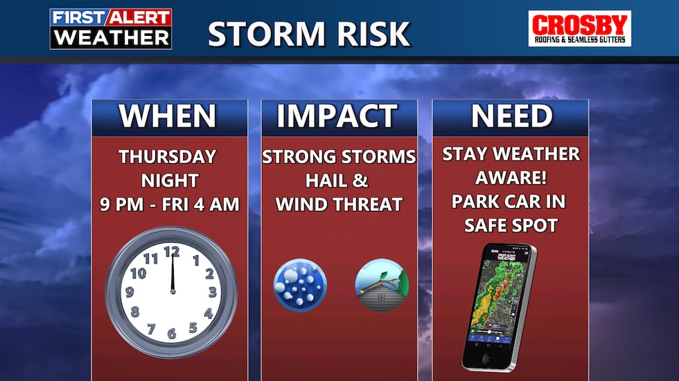
AUGUSTA, Ga. (WRDW/WAGT) - FIRST ALERT Severe weather is possible tonight into Friday morning. Strong wind and large hail will be possible in a few storms late tonight. The Storm Prediction Center currently has the region in a slight risk, level 2 out of 5. Timing of storms will be between 9 pm and 4 am. Stay weather aware!
Storms will exit the CSRA before sunrise Friday morning. Most of Friday looks dry with only an isolated chance for a shower or storm in the afternoon. Temperatures will be warm again and reach the mid-80s in the afternoon.
Rain looks likely for Mother’s Day Weekend. This will be thanks to a stalled front over the region and a cut-off upper level low oriented over the Southeast. The cut-off low will continuously sling Gulf moisture over the front this weekend into next week bringing very beneficial rain to the region. There is a marginal to slight flash flood risk over the CSRA Saturday, Sunday, and Monday. Flood prone areas should be on alert for the potential of minor issues.
Saturday doesn’t look like an all day washout rain event, but you have a high chance of seeing rain at some point during the morning/afternoon - expect hit or miss showers during the day. The highest rain chances will be Saturday night into Sunday. Heavy rain leading to some flooding issues is the main concern with rain this weekend. High temperatures will be cooler this weekend in the mid-70s thanks to cloudy skies and rain chances during the day.
Next week stays wet through Tuesday as the cut-off upper low remains detached from the main jet stream pattern and nearly stationary. There is a slight flood risk in place across the CSRA Monday and Tuesday. It looks like the cut-off upper low will finally get picked up by the jet stream and push east by next Wednesday. Keep it here for updates!
Copyright 2025 WRDW/WAGT. All rights reserved.


